
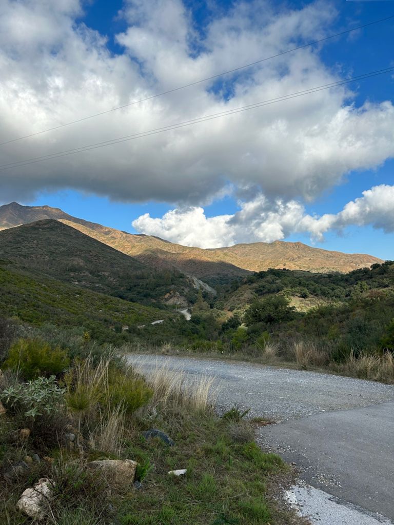
¡NOTA! Terral Bike Rental S.L no se hace responsable del estado de las carreteras como caminos de tierra. Respete las señales de tráfico y el entorno natural por donde discurran.
NOTE! Terral Bike Rental S.L. is not responsible for the condition of the roads such as dirt roads. Respect traffic signs and the natural environment where they pass.
Pueden encontrar todas nuestras rutas en las Apps Strava y Komoot. En cualquiera de las apps puede descargar el archivo GPX. Puede descargar estas apps en la Play Store o en la App Store.
You can find all our routes on the App Strava and Komoot. Gpx file can be downloaded on both apps.
ROAD BIKE
FROM TERRAL BIKE SHOP
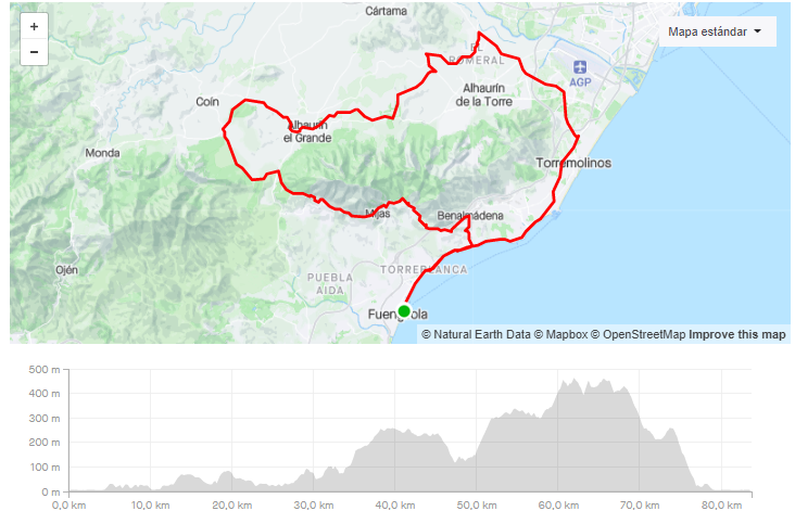
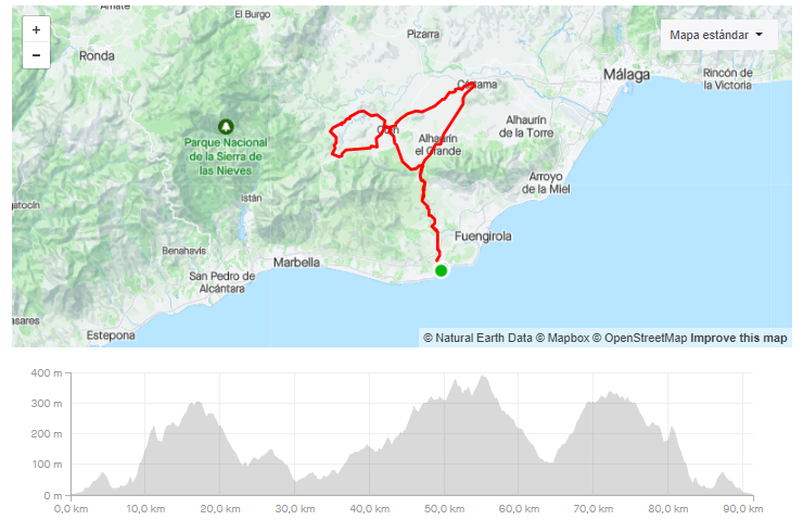
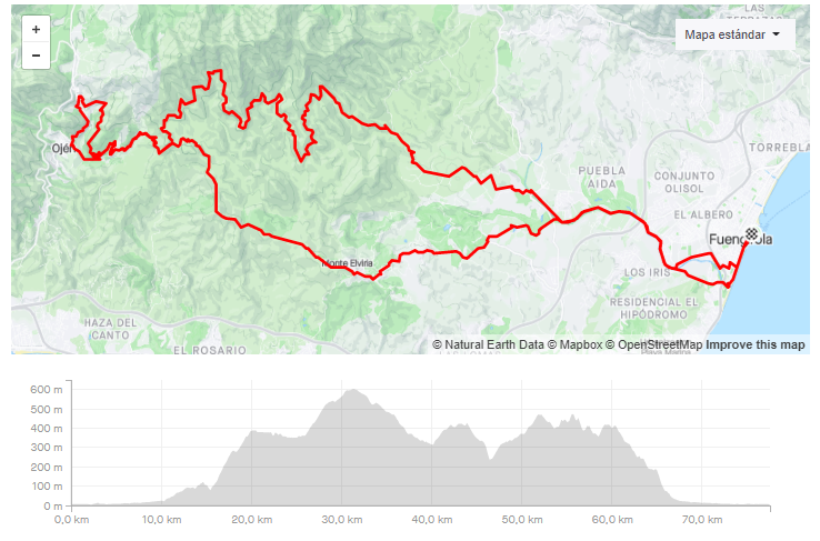
1. TERRAL BIKE SHOP – EL 8
-
DISTANCIA/DISTANCE: 70,97km.
-
DESNIVEL POSITIVO/POSITIVE SLOPE: 1.099m
-
Our LINK in Strava.
- Our LINK in Komoot.
-
DIFICULTAD/DIFFICULTY: Media.
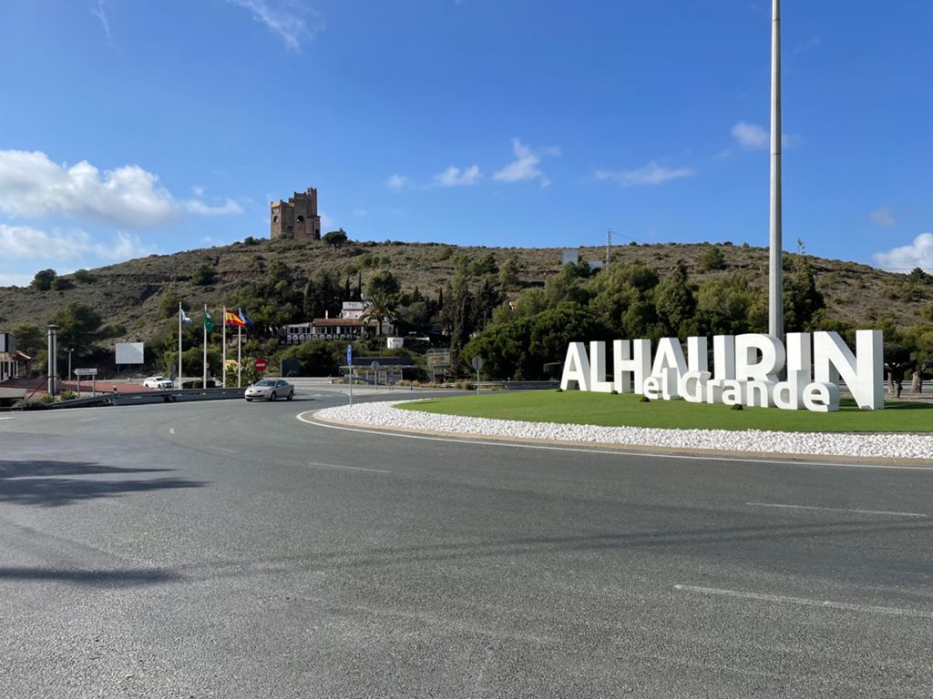
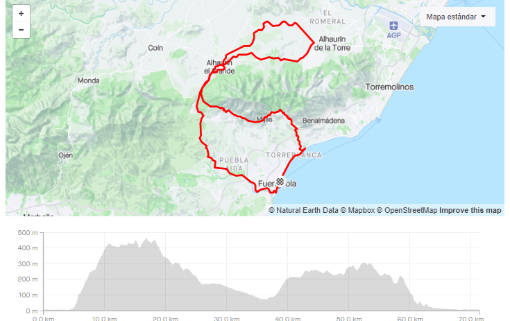
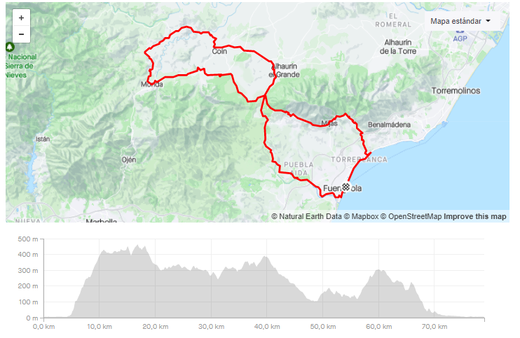
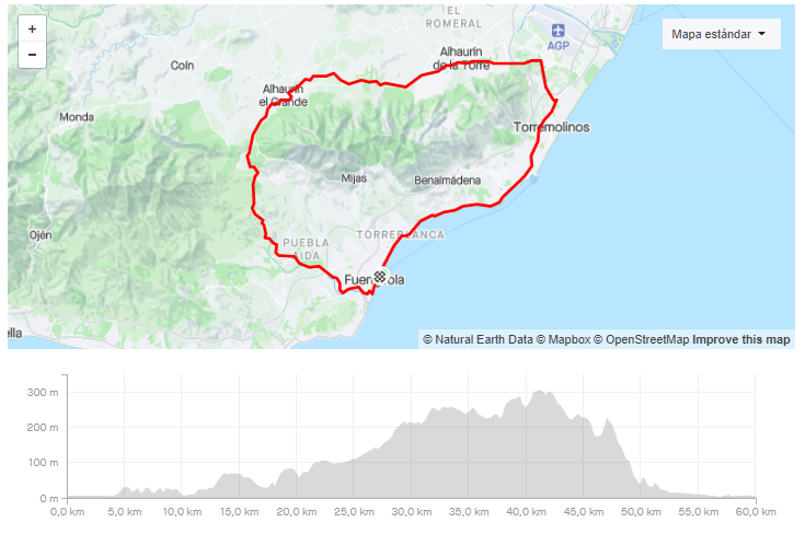
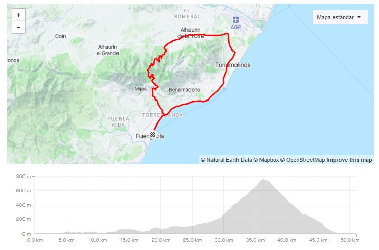
2. TERRAL BIKE SHOP – EL ROMERAL – COIN
-
DISTANCIA/DISTANCE: 83,75km
-
DESNIVEL POSITIVO/POSITIVE SLOPE: 1.286m.
- Our LINK in Strava
- Our LINK in Komoot.
- DIFICULTAD/DIFFICULTY: Media.
- VIDEO – https://www.relive.cc/view/vevYQoRjmyv
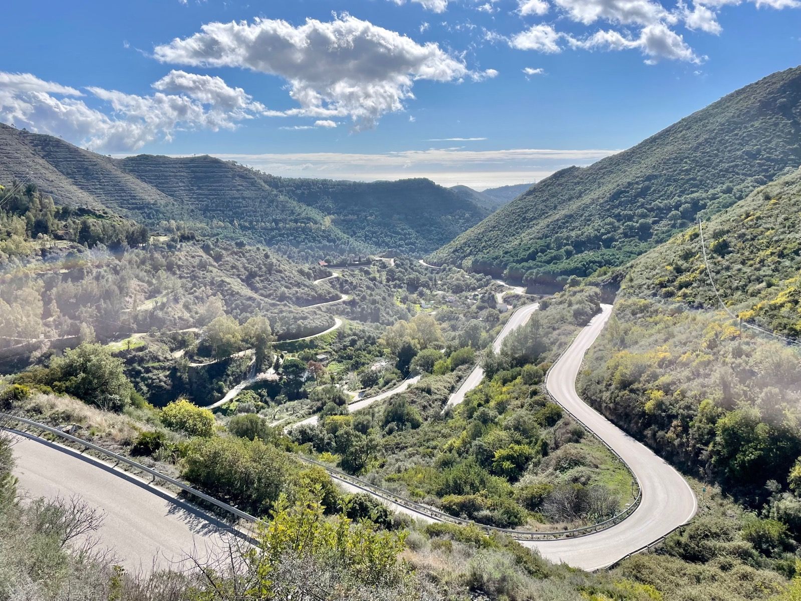
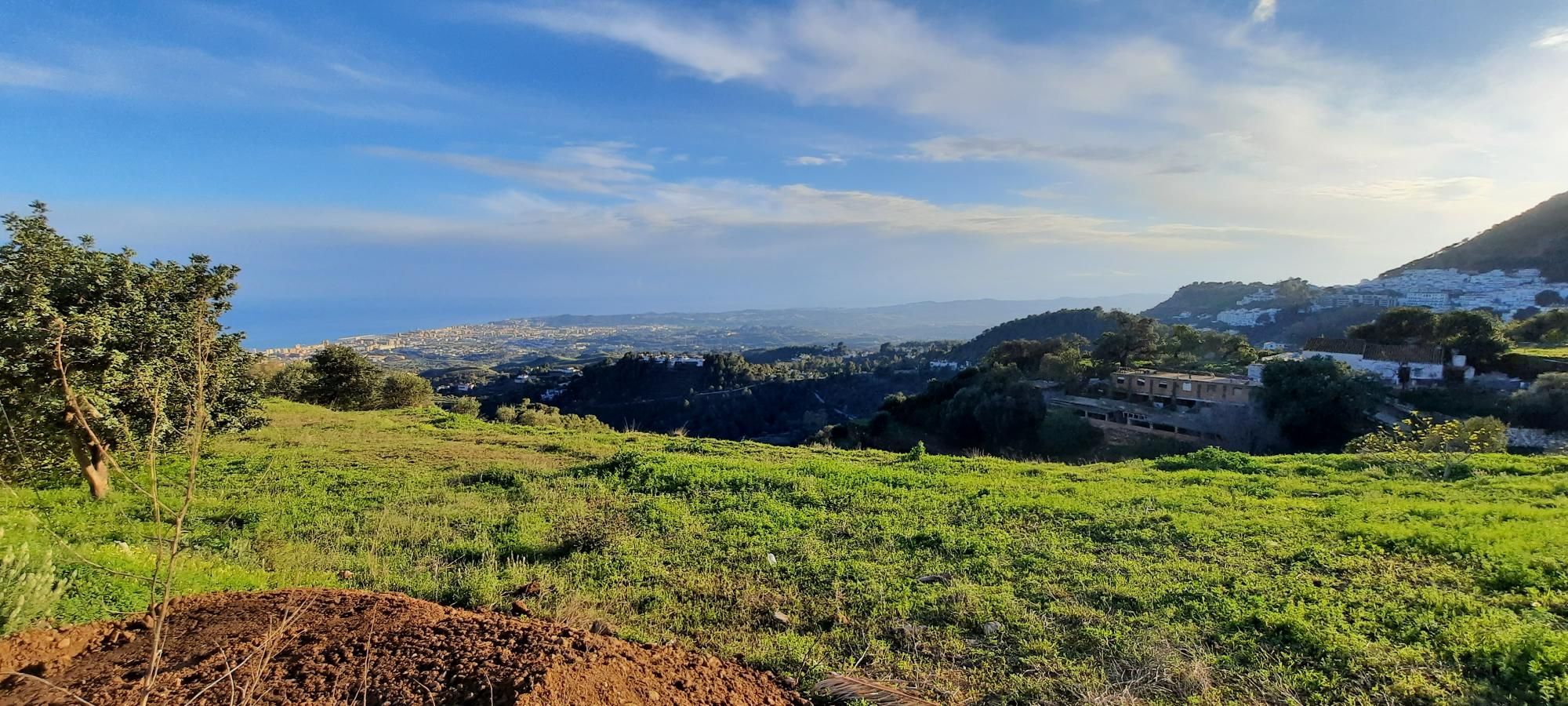
Una ruta sencilla sin grandes subidas para mover las piernas. Su comienzo es a traves de la carretera de la costa dirección Torremolinos. Una vez llegado a Torremolinos coge dirección a los Alhaurines, Mijas, Benalmadena hacía Fuengirola. La parte mas dura de esta ruta es el tramo de Alhaurin el Grande hacia Mijas, una subida constante con pendientes poco pronunciadas.
A simple route without big climbs to move the legs. Its beginning is through the coast road towards Torremolinos. Once you reach Torremolinos, take the direction of the Alhaurines, Mijas, and Benalmadena towards Fuengirola. The hardest part of this route is the stretch of Alhaurin el Grande towards Mijas, a constant climb with little steep slopes.
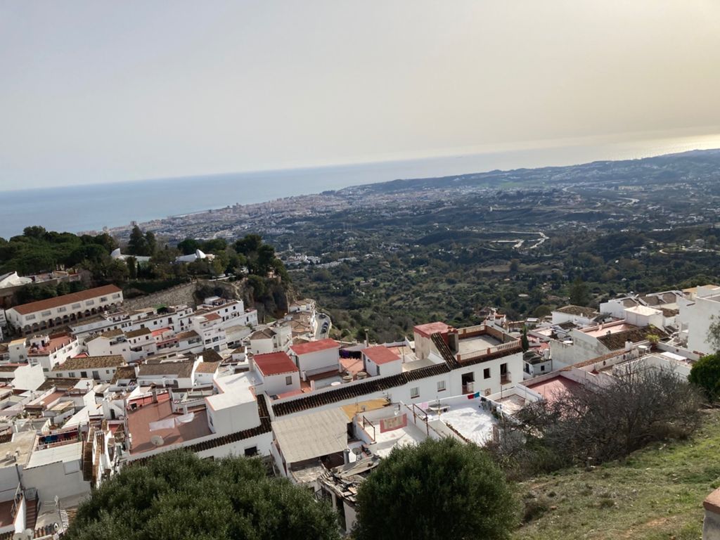
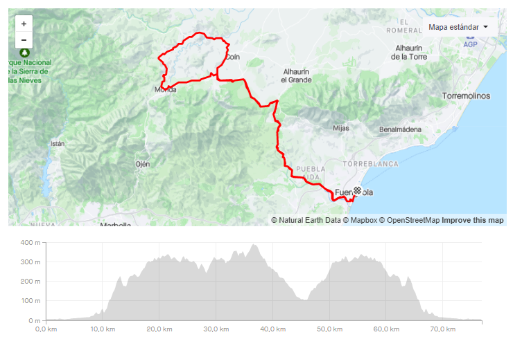
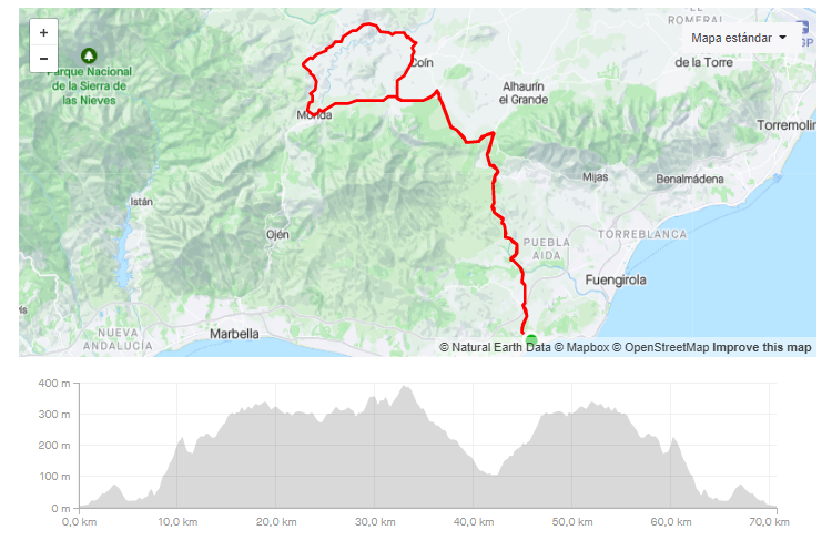
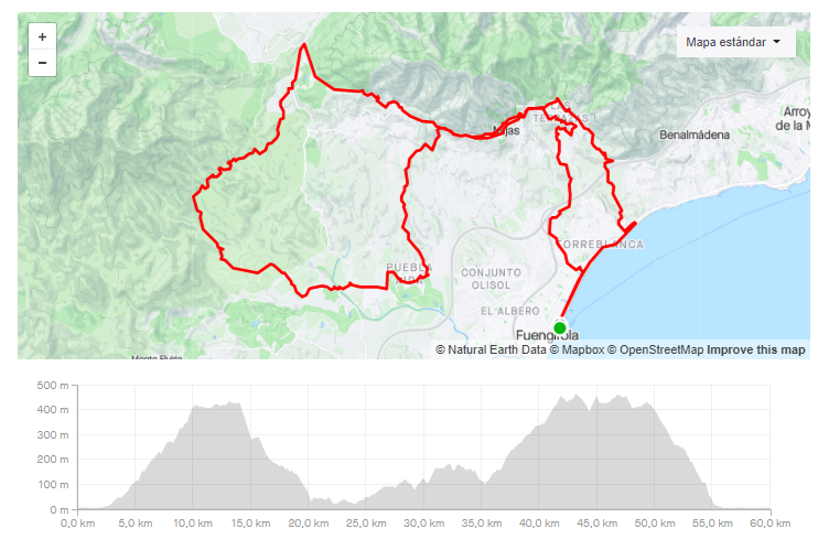
3. TERRAL BIKE SHOP – MONDA – GUARO – COIN
-
DISTANCIA/DISTANCE: 76,91km
-
DESNIVEL POSITIVO/POSITIVE SLOPE: 1.243m.
- Our LINK in Strava.
- Our LINK in Komoot.
- DIFICULTAD/DIFFICULTY: Media.
- VIDEO – https://www.relive.cc/view/vYvEKADNGG6

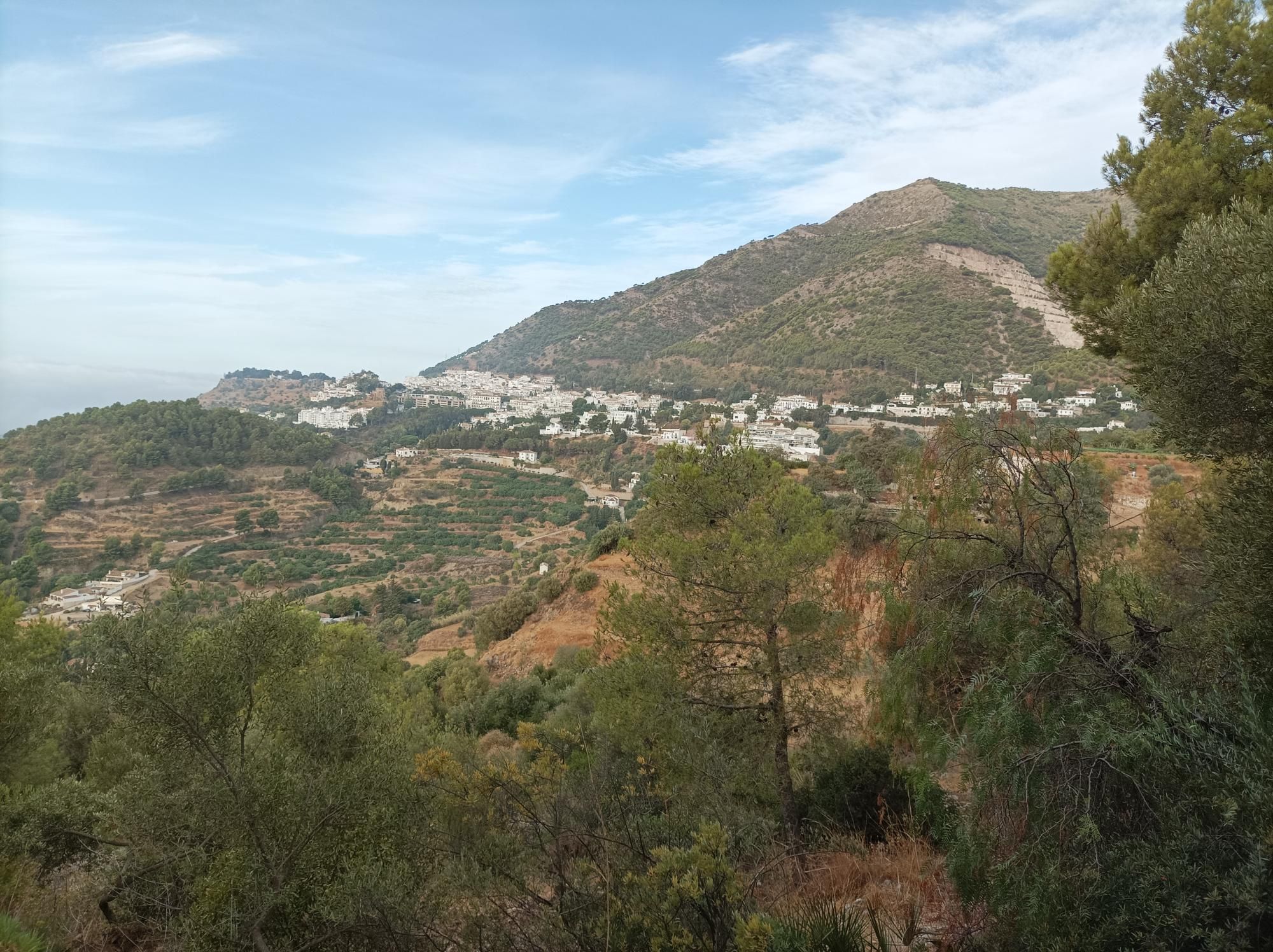
La ruta que siempre recomendamos a cualquiera que viene nuevo a esta zona. Carreteras tranquilas y de buen asfalto en las zonas de Monda, Guaro y Coin. El único punto que puede ser conflictivo con el tráfico es el comienzo de la ruta hasta llegar a su primera subida, El puerto de los Pescadores.
The route we always recommend to anyone coming new to this area. Quiet and good asphalt roads in the areas of Monda, Guaro and Coin. The only point that can be conflictive with traffic is the beginning of the route until reaching its first climb, Los Pescadores Port.
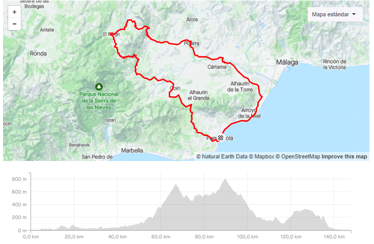
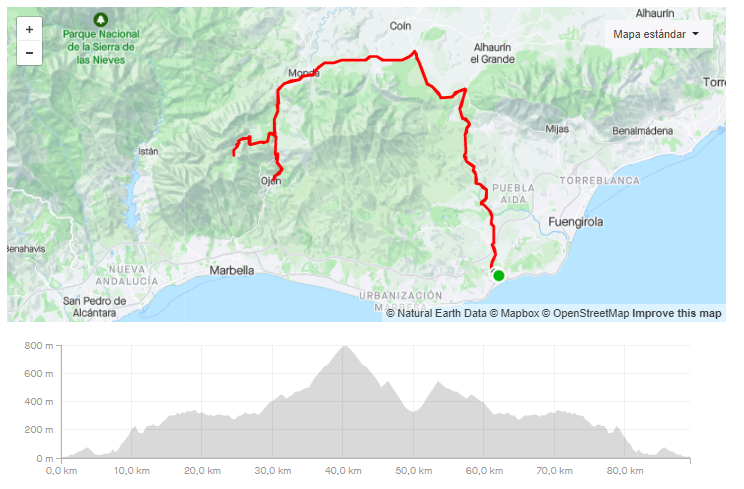
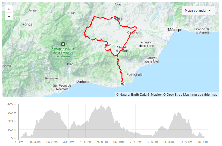
4. TERRAL BIKE SHOP – PIZARRA – EL BURGO – COIN
-
DISTANCIA/DISTANCE: 147,91km.
-
DESNIVEL POSITIVO/POSITIVE SLOPE: 2.350m.
- Our LINK in Strava.
- Our LINK in Komoot.
- DIFICULTAD/DIFFICULTY: Alta.
- VIDEO – https://www.relive.cc/view/vrqoPknJJKv
Fuengirola – Torremolinos – Pizarra – El Burgo -Fuengirola. Este es el itinerario que sigue una de las rutas con mayor dificultad, de todas las que proponemos.
Con comienzo en Fuengirola por la carretera de la costa hasta Torremolinos. Una vez llegado a Torremolinos nos adentramos hacia el interior por el Valle del Guadalhorce. Comenzaremos a subir hasta Casarabonela para terminar en Puerto Martinez. Una vez acabada la subida comenzaremos con una bajada con asfalto en buen estado.
Con la finalización de esta bajada llegaremos al Burgo y finalizaremos la ultima del dia, con la subida al Puerto de las Abejas. Una vez acabada, nos quedara la última y favorable parte de esta ruta.
Fuengirola – Torremolinos – Pizarra – El Burgo -Fuengirola. This is the itinerary that follows one of the most difficult itineraries, of all the ones we offer.
Starting in Fuengirola by the coast road to Torremolinos. Once arrived in Torremolinos we entered towards the interior by the Guadalhorce Valley. We will start to climb to Casarabonela to finish in Puerto Martinez. Once the climb is completed we will start with a descent with good asphalt.
After completing this descent, we will arrive at Burgo and finish the last day with the climb to the Port of Bees. Once finished, we will have the last and most favourable part of this route.
5. TERRAL BIKE SHOP – CARVAJAL CLIMB – MONDA – COIN – ALHAURIN – FUENGIROLA
-
DISTANCIA/DISTANCE: 78,93km
-
DESNIVEL POSITIVO/POSITIVE SLOPE: 1.463m.
- Our LINK in Strava.
- Our LINK in Komoot.
- DIFICULTAD/DIFFICULTY: Media / Alta.
- VIDEO – https://www.relive.cc/view/v4OGgRMK7mO
Una ruta clásica en las grupetas de la zona, primera subida exigente para abandonar la costa y adentrarnos en el interior de la provincia. Monda, Guaro y Coin son algunas de las localidades por las que pasa esta ruta.
A classic route in the grupeta´s of the area, the first demanding climb to leave the coast and enter the interior of the province. Monda, Guaro and Coin are some of the towns along this route.
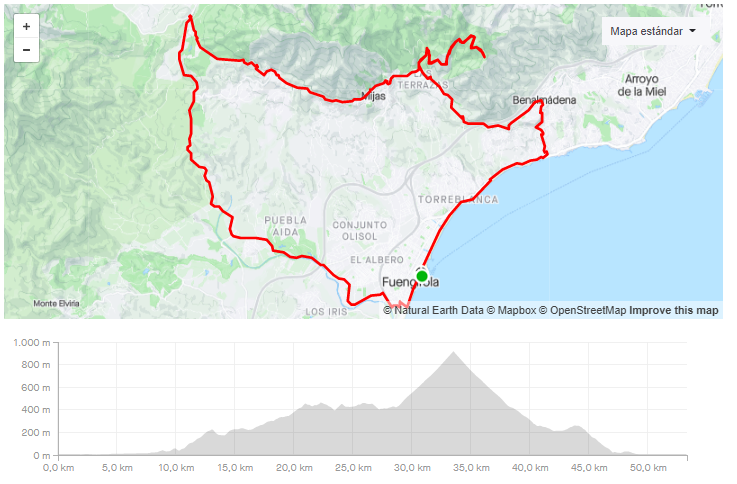
6. TERRAL BIKE SHOP – REPETIDOR – VENTA LOS MORENOS
-
DISTANCIA/DISTANCE: 53,34km
-
DESNIVEL POSITIVO/POSITIVE SLOPE: 1.289m.
- Our LINK in Strava.
- Our LINK in Komoot.
- DIFICULTAD/DIFFICULTY: Alta.
- VIDEO – https://www.relive.cc/view/vYvEKADD3w6
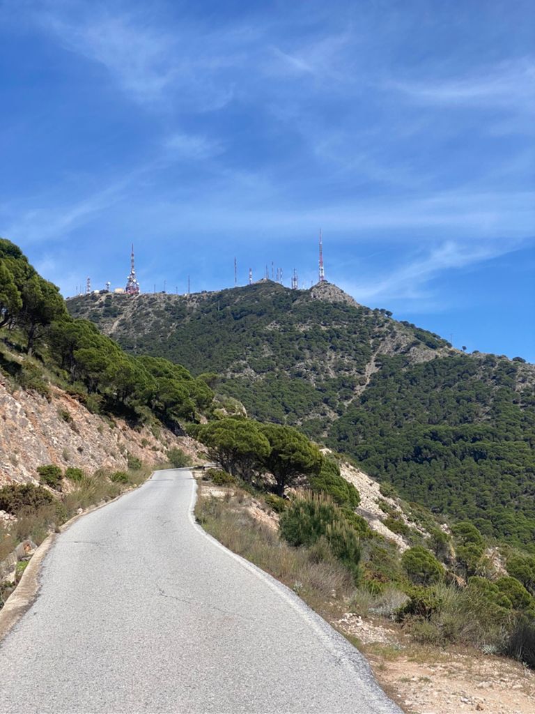
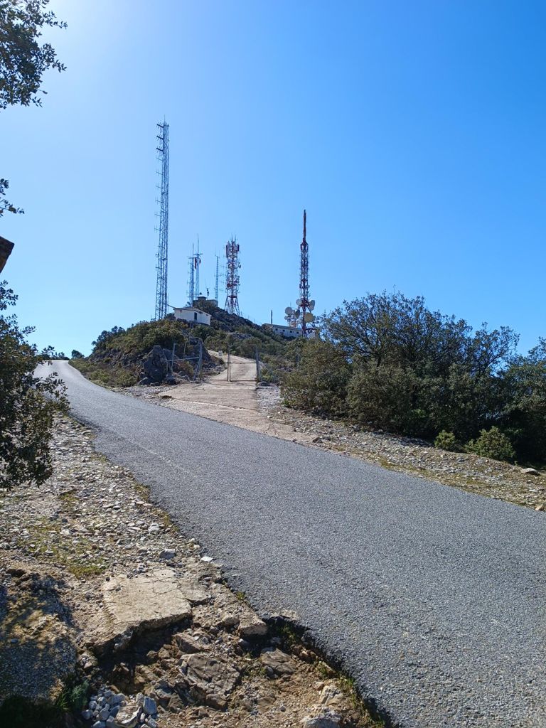
Para todos los que quieren subir al Repetidor de Mijas hemos preparado esta ruta por la zona mas comoda.
For all those who want to climb the Mijas Repeater, we have prepared this route through the most comfortable area.
7. TERRAL BIKE SHOP – AROUND THE MOUNTAINS
-
DISTANCIA/DISTANCE: 60,04km
-
DESNIVEL POSITIVO/POSITIVE SLOPE: 729m.
- Our LINK in Strava.
- Our LINK in Komoot.
- DIFICULTAD/DIFFICULTY: Facil / Media.
- VIDEO – https://www.relive.cc/view/v26M7X3gYEv
Ruta de dificultad moderadad, donde se rodea la sierra de Mijas y Alhaurin. Los primeros 40 kilometros van con una suave ascensión hasta el Puerto de los Pescadores.
Route of moderate difficulty, where the Sierra de Mijas and Alhaurin are surrounded. The first 40 km go with a gentle ascent to Puerto de Los Pescadores.
8. TERRAL BIKE SHOP – MIJAS – CARTAMA – FUENGIROLA
- DISTANCIA/DISTANCE: 75.95km
- DESNIVEL POSITIVO/POSITIVE SLOPE: 1264m.
- Our LINK in Strava.
- Our LINK in Komoot.
- DIFICULTAD/DIFFICULTY: Media.
- VIDEO – https://www.relive.cc/view/vYvEKAQ4Pw6

Ruta con subida a Benalmadena y Mijas Pueblo. Desde alli bordeamos el Valle del Azahar por Alhaurin el Grande, Cartama y Coin. Bajamos por el Puerto de Pescadores.
Route with the ascent to Benalmadena and Mijas Pueblo. From there we border the Azahar Valley by Alhaurin el Grande, Cartama and Coin. We went down the Fisherman’s Port.
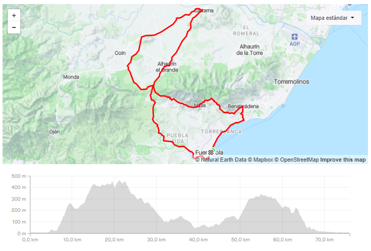
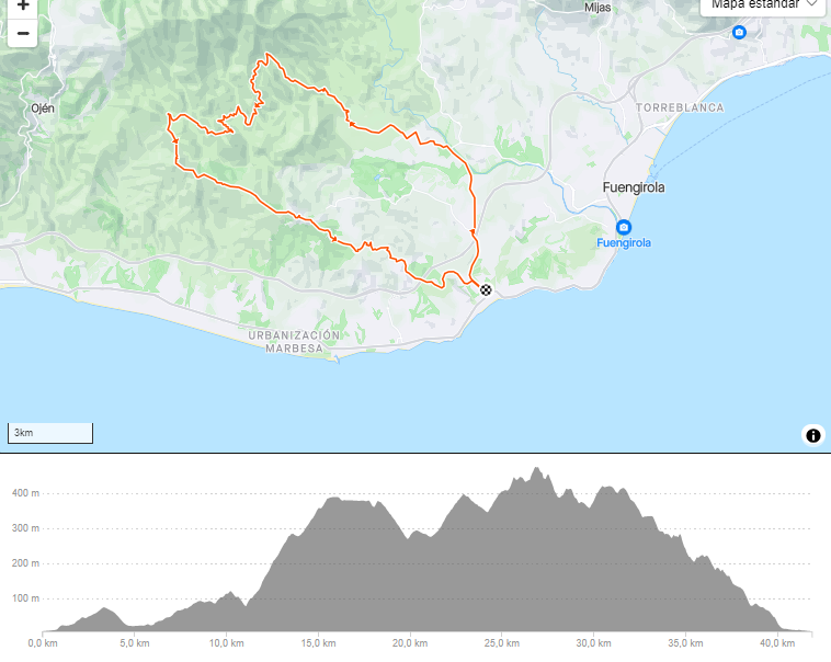
9. TERRAL BIKE SHOP – BOBASTRO – ARDALES – CASARABONELA

- DISTANCIA/DISTANCE: 173.00km
- DESNIVEL POSITIVO/POSITIVE SLOPE: 2800 m.
- Our LINK in Strava.
- Our LINK in Komoot.
- DIFICULTAD/DIFFICULTY: Media / Alta

Esta ruta en bicicleta de 173,35 km con un desnivel acumulado de 2.800 metros ofrece un recorrido desafiante a través de impresionantes paisajes. Pasa por localidades como Bobastro, Ardales y Casarabonela, combinando tramos exigentes con vistas espectaculares. A lo largo del trayecto, encontrarás segmentos destacados que pondrán a prueba tu resistencia y habilidades ciclistas.
This 173.35 km cycling route with a total elevation gain of 2,800 meters offers a challenging ride through stunning landscapes. It passes through towns like Bobastro, Ardales, and Casarabonela, combining demanding sections with breathtaking views. Throughout the journey, you’ll encounter notable segments that will test your endurance and cycling skills.
FROM LA CALA DE MIJAS
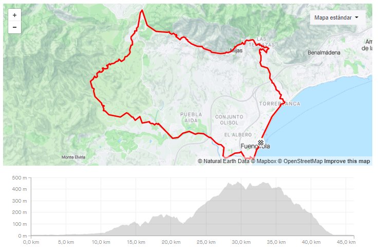
10. LA CALA – REPETIDOR – BENALMADENA PUEBLO – LA CALA
-
DISTANCIA/DISTANCE: 59,85km.
-
DESNIVEL POSITIVO/POSITIVE SLOPE: 1472.m.
- Our LINK in Strava.
- Our LINK in Komoot.
- DIFICULTAD/DIFFICULTY: Alta.
- VIDEO – https://www.relive.cc/view/vrqoPk1dEyv
Para todos los que quieren subir al Repetidor de Mijas y estan en La Cala de Mijas hemos preparado esta ruta por la zona mas comoda. Vuelta a La Cala de Mijas por el Chaparral.
For all those who want to climb the Mijas Repeater and are in La Cala de Mijas, we have prepared this route through the most comfortable area. Back to La Cala de Mijas by the Chaparral.
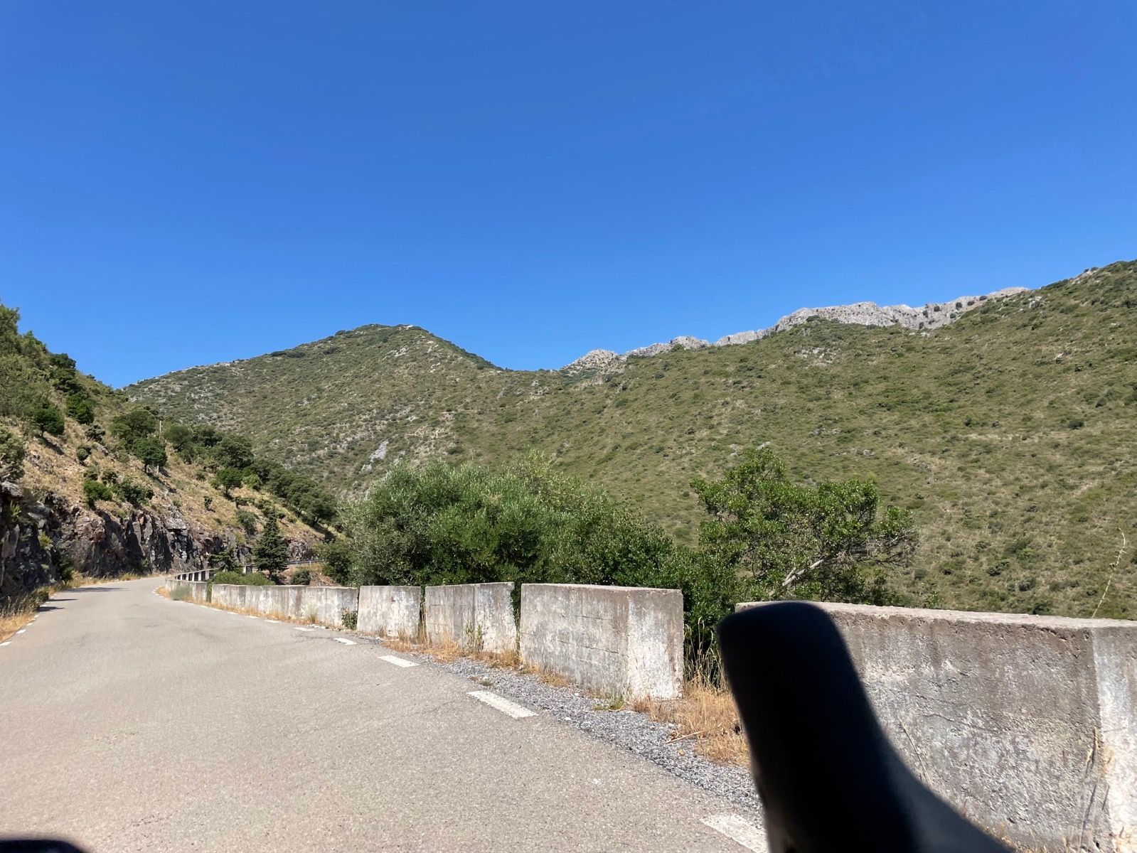
11. LA CALA – REFUJIO DE JUANAR – OJEN
-
DISTANCIA/DISTANCE: 89,28km.
-
DESNIVEL POSITIVO/POSITIVE SLOPE: 1720m.
- Our LINK in Strava.
- Our LINK in Komoot.
- DIFICULTAD/DIFFICULTY: Alta.
- VIDEO – https://www.relive.cc/view/vJOKZpk9n5v
Una ruta dura, la cual merecerá la pena por sus buenas vistas en ambas subidas, la subida al Refugio de Juanar y los Caracolillos de Ojen. Carreteras tranquilas en gran parte de la ruta.
A hard route, which will be worth it for its good views on both climbs, the ascent to the Refugio de Juanar and the Caracolillos de Ojen. Quiet roads throughout much of the route.
12. LA CALA – MONDA – GUARO – COIN
-
DISTANCIA/DISTANCE: 70,77km.
-
DESNIVEL POSITIVO/POSITIVE SLOPE: 1219m.
- Our LINK in Strava
- Our LINK in komoot.
- DIFICULTAD/DIFFICULTY: Media.
- VIDEO – https://www.relive.cc/view/v4OGgRJRx5O
La ruta que siempre recomendamos a cualquiera que viene nuevo a esta zona. Carreteras tranquilas y de buen asfalto en las zonas de Monda, Guaro y Coin.
The route we always recommend to anyone coming new to this area. Quiet and good asphalt roads in the areas of Monda, Guaro and Coin.
13. LA CALA – CARTAMA – MONDA
-
DISTANCIA/DISTANCE: 91,40km
-
DESNIVEL POSITIVO/POSITIVE SLOPE: 1568m.
- Our LINK in Strava.
- Our LINK in Komoot.
- DIFICULTAD/DIFFICULTY: Media / Alta.
- VIDEO – https://www.relive.cc/view/vYvEKAQ3GG6

Ruta exigente por los 3 puertos de Montaña por los cuales tendrás que pasar. El asfalto es de buena calidad en todo el trayecto.
Demanding route through the 3 mountain passes through which you will have to pass. The asphalt is of good quality throughout the journey.
14. LA CALA – CARTAMA – PIZARRA – COIN
-
DISTANCIA/DISTANCE: 113,34km.
-
DESNIVEL POSITIVO/POSITIVE SLOPE: 1817m.
- Our link in Strava.
- Our LINK in Komoot.
- DIFICULTAD/DIFFICULTY: Alta.
- VIDEO – https://www.relive.cc/view/vmqXwNn3go6
Ruta que acumula un desnivel positivo alto, en una zona muy tranquila como es la zona de Coin, Alozaina y el cruce de Casarabonela. Regreso por el Valle del Guadalhorce.
A route that accumulates a high positive slope, in a very quiet area such as the area of Coin, Alozaina and the crossing of Casarabonela. Return by the Guadalhorce Valley.
GRAVEL BIKE
FROM TERRAL BIKE SHOP
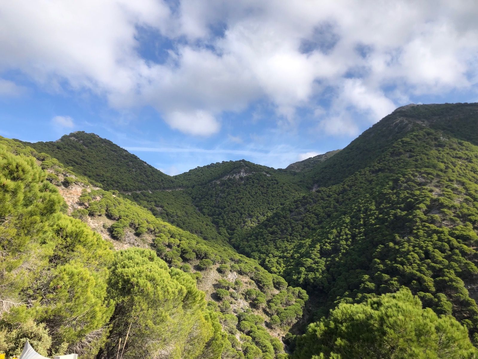
Creamos una serie de tracks en los que en alguna epoca del año seria imposible hacer debido a que estos tracks cruzan algunos rios. Es por este motivo que queda prohibido cruzar zonas de aguas, rios o lagos con las E-Bike. Todas las rutas marcadas con los emojis (⚠️💧)están prohibidas realizarlas en E-Bikes si los ríos crecen.
Recuerde llevar suficiente agua sobre todo en meses de calor y algo de comida, son rutas de algo mas de 3 horas la mayoria.
We created a series of tracks that would be impossible to ride at certain times of the year because they cross some rivers. For this reason, crossing water areas, rivers, or lakes with E-Bikes is prohibited. All the tracks signed with the emojis (⚠️💧) are totally prohibited for E-Bikes when rivers get more caudal.
Remember to take enough water and some food, most of the routes last 3 hours or more.
15. TERRAL BIKE SHOP – TOXICOMANOS – OJEN- MONDA – BP ALHAURIN
-
DISTANCIA/DISTANCE: 78,31km
-
DESNIVEL POSITIVO/POSITIVE SLOPE: 1.373m.
- Our LINK in Strava.
- Our LINK in Komoot.
- DIFICULTAD/DIFFICULTY: Media.
- VIDEO – https://www.relive.cc/view/vXvL1PEMw7O
Ruta de dificultad media. Primera parte de asfalto hasta Ojén. Una vez alli se tome camino hasta Fuengirola pista a traves, la cual se encuentra en buenas condiciones.
Route of medium difficulty. The first part of asphalt to Ojén. Once there, take the gravel road to Fuengirola, which is in good condition.
16.⚠️💧TERRAL BIKE SHOP – CERNICALO – LA MAIRENA – LA CALA – FUENGIROLA

-
DISTANCIA/DISTANCE: 51,59 km.
-
DESNIVEL POSITIVO/POSITIVE SLOPE: 956 m.
- Our LINK in Strava.
- Our LINK in Komoot.
- DIFICULTAD/DIFFICULTY: Media.
- VIDEO – https://www.relive.cc/view/vZqNERAW136

Esta ruta es una de nuestras favoritas. Los primeros 15 kilómetros transcurren a lo largo del río, lo cual, en época de lluvias, no sería posible recorrer. En el km 16,5 tenemos un punto en el que debemos prestar atención, ya que cruzamos la carretera comarcal A-7035.
Una vez que hayamos cruzado, entramos en el segundo bucle, donde nos espera alguna rampa exigente del 21%. Si decides hacerla más corta, al llegar al km 26,5 debes continuar recto hacia Fuengirola, abandonando el recorrido. Si decides seguir, el tercer bucle es el más bonito para nosotros, ya que atravesamos uno de los últimos bosques mediterráneos que aún se conservan.
En la parte final pasamos por La Cala de Mijas, un buen lugar para tomar un aperitivo.
This route is one of our favorites. The first 15 kilometers run along the river, which would not be possible to ride during the rainy season. At kilometer 16.5, there is a point where we need to be especially careful as we cross the A-7035 regional road.
Once we have crossed, we enter the second loop, where a challenging 21% incline awaits. If you prefer a shorter ride, at kilometer 26.5, you should continue straight towards Fuengirola, leaving the route. However, if you decide to continue, the third loop is the most beautiful for us, taking you through one of the last remaining Mediterranean forests.
In the final stretch, we pass through La Cala de Mijas, a great spot to stop for a snack.
17.TERRAL BIKE SHOP – OJEN – ELVIRIA
-
DISTANCIA/DISTANCE: 77,56km.
-
DESNIVEL POSITIVO/POSITIVE SLOPE: 1.406m.
- Our LINK in Strava.
- Our LINK in Komoot.
- DIFICULTAD/DIFFICULTY: Media.
- VIDEO – https://www.relive.cc/view/vJOKZxjA95v
Ruta que transcurre atraves de Sierra Parda, se sube la conocida Pileta hasta bajar a Ojén. De regreso de toma camino de Elvira-La Cala Golf.
A route that passes through Sierra Parda, you climb the well-known Pileta until you get off to Ojén. Back on the way to Elvira-La Cala Golf.
18.TERRAL BIKE SHOP – ENTRERIOS – GARDEN CENTER -OSUNILLAS
-
DISTANCIA/DISTANCE: 46,12km.
-
DESNIVEL POSITIVO/POSITIVE SLOPE: 895m.
- Our LINK in Strava.
- Our LINK in Komoot.
- DIFICULTAD/DIFFICULTY: Media.
- VIDEO – https://www.relive.cc/view/v7O9J5gKVQ6
Ruta que va camino del Puerto de Pescadores por pista, una vez alli, toma camino de Mijas para bajar por Osunillas. Bajada divertida.
Route that goes on the way to Puerto de Pescadores by track, once there, take the way to Mijas to go down Osunillas. Fun descent.
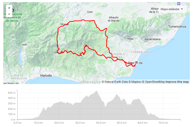
19.TERRAL BIKE SHOP – LOS PACOS – MIJAS – CARVAJAL

-
DISTANCIA/DISTANCE: 23,98 km
-
DESNIVEL POSITIVO/POSITIVE SLOPE: 483 m.
- Our LINK in Strava.
- Our LINK in Komoot.
- DIFICULTAD/DIFFICULTY: Media.

Esta ruta en bicicleta de 23,98 km, con un desnivel acumulado de 483 metros, ofrece un recorrido variado desde Los Pacos hasta Mijas y Carvajal. Combina ascensos desafiantes con descensos emocionantes, pasando por paisajes espectaculares. A lo largo del trayecto, encontrarás segmentos destacados como la subida a la Urbanización Torreblanca del Sol y la exigente ascensión a Osunillas y la Ermita de San Antón, que pondrán a prueba tu resistencia y habilidades ciclistas.
This 23.98 km cycling route, with a total elevation gain of 483 meters, offers a diverse ride from Los Pacos to Mijas and Carvajal. It combines challenging climbs with thrilling descents, passing through stunning landscapes. Along the way, you’ll encounter notable segments such as the climb to Urbanización Torreblanca del Sol and the demanding ascent to Osunillas and Ermita de San Antón, which will test your endurance and cycling skills.
20.TERRAL SHOP – BP ALHAURIN – JARAPALOS – MIJAS

-
DISTANCIA/DISTANCE: 60,81 km
-
DESNIVEL POSITIVO/POSITIVE SLOPE: 1293 m.
- Our LINK in Strava.
- Our LINK in Komoot.
- DIFICULTAD/DIFFICULTY: Media/ Alta

Esta ruta de gravel de 54,8 km y 1.218 m de desnivel ofrece un recorrido variado desde Fuengirola hasta Alhaurín de la Torre, pasando por Jarapalos y Mijas. Con tramos pavimentados y de tierra, incluye ascensos exigentes, como la subida a Jarapalos (5,8 km al 8%), y descensos técnicos que pondrán a prueba la destreza del ciclista. Es una opción ideal para quienes buscan un desafío moderado en un entorno natural con vistas panorámicas.
This 54.8 km gravel route with 1,218 m of elevation gain offers a diverse ride from Fuengirola to Alhaurín de la Torre, passing through Jarapalos and Mijas. Featuring both paved and dirt sections, it includes demanding climbs, such as the 5.8 km ascent to Jarapalos (8% gradient), and technical descents that challenge cycling skills. It’s an excellent choice for those seeking a moderate challenge in a scenic natural setting.
21.TERRAL SHOP – TORREMOLINOS – JARAPALOS – TORREBLANCA
-
DISTANCIA/DISTANCE: 51,06km
-
DESNIVEL POSITIVO/POSITIVE SLOPE: 944m.
- Our LINK in Strava.
- Our LINK in Komoot.
- DIFICULTAD/DIFFICULTY: Media.
- VIDEO – https://www.relive.cc/view/v7O9J5gPBQ6
Ruta que transcurre en su practica totalidad por asfalto hasta la entrada de Jarapalos. Se cruza la Sierra de Mijas de norte a sur.
A route that runs almost entirely on asphalt until the entrance of Jarapalos. The Sierra de Mijas is crossed from north to south.
22.TERRAL BIKE SHOP – CANTERAS- ERMITA 3 CRUCES – MALAGA – FUENGIROLA

-
DISTANCIA/DISTANCE: 111,48 km.
-
DESNIVEL POSITIVO/POSITIVE SLOPE: 2,182 m.
- Our LINK in Strava.
- Our LINK in Komoot.
- DIFICULTAD/DIFFICULTY: ALTA
- VIDEO – https://www.relive.cc/view/vMv8g8jR1Nq

Esta ruta de ciclismo de 111,48 km y 2.182 m de desnivel conecta las Canteras con la Ermita de las Tres Cruces en Málaga. Combina tramos pavimentados y de tierra, incluyendo ascensos exigentes como la subida a la Ermita de las Tres Cruces, con pendientes de hasta el 13,9%. Es ideal para ciclistas que buscan un desafío en un entorno natural con vistas panorámicas.
This 111.48 km cycling route with 2,182 m of elevation gain connects Canteras to the Ermita de las Tres Cruces in Málaga. It combines paved and dirt sections, including demanding climbs like the ascent to the Ermita de las Tres Cruces, with gradients up to 13.9%. It’s ideal for cyclists seeking a challenge in a natural setting with panoramic views.
23.⚠️💧TERRAL BIKE SHOP – LOS PACOS – LOMA DEL FALMENCO – GARDEN CENTER
-
DISTANCIA/DISTANCE: 60,09km.
-
DESNIVEL POSITIVO/POSITIVE SLOPE: 1.394m.
- Our LINK in Strava.
- Our LINK in Komoot.
- DIFICULTAD/DIFFICULTY: Media.
- VIDEO – https://www.relive.cc/view/vmqXwBzPEo6
Ruta que consta de 2 partes, 1ª parte con subida a Mijas por Los Pacos. 2ª parte o intermedia que transcurre por Valtocado y Puerto de Pescadores.
A route consisting of 2 parts, 1st part with a climb to Mijas by Los Pacos. 2nd part or intermediate runs through Valtocado and Puerto de Pescadores.
24.TERRAL BIKE SHOP – TOXICOMANOS – ELVIRIA – LA CALA – CHAPARRAL

-
DISTANCIA/DISTANCE: 57,88km.
-
DESNIVEL POSITIVO/POSITIVE SLOPE: 1134 m.
- Our LINK in Strava.
- Our LINK in Komoot.
- DIFICULTAD/DIFFICULTY: Media.
- VIDEO – https://www.relive.cc/view/v1OwG9kBLXO
Esta es una de nuestras rutas favoritas, subiendo por el centro de drogodependencia. Desde alli podremos contemplar las buenas vistas de toda la costa. Cruzaremos uno de los ultimos bosque mediterráneos que aún se conservan en buen estado.
This is one of our favourite routes, up the Drug Addiction Center of Mijas. From there we can see the good views of the entire coast. We will cross one of the last Mediterranean forests that are still in good condition.
25.⚠️💧AROUND THE HILLS

-
DISTANCIA/DISTANCE: 29,30km.
-
DESNIVEL POSITIVO/POSITIVE SLOPE: 543 m.
- Our LINK in Strava.
- Our LINK in Komoot.
- DIFICULTAD/DIFFICULTY: Facil.

Una ruta sencilla por las colinas de Mijas y Fuengirola. Buenas vistas de la costa en el transcurso.
Easy route on the Fuengirola and Mijas Hills. Nice coastal views on the way.
26. ⚠️💧JULIO IGLESIAS TOUR

-
DISTANCIA/DISTANCE: 61,20 km.
-
DESNIVEL POSITIVO/POSITIVE SLOPE: 1168 m.
- Our LINK in Strava.
- Our LINK in Komoot.
- DIFICULTAD/DIFFICULTY: Media.

La ruta discurre a lo largo del río Fuengirola durante unos 10 km. Abandonamos el río para adentrarnos en uno de los múltiples campos de golf de la zona y, una vez allí, seguimos hacia una de las zonas más bonitas del lugar: el bosque mediterráneo de Elvira. Cruzaremos la Sierra Parda para luego descender hacia el río Fuengirola.
Este tour recibe el nombre de Julio debido a que pasamos por su lujosa mansión en Elvira.
The route follows the Fuengirola River for about 10 km. We leave the river behind to enter one of the many golf courses in the area and, once there, continue towards one of the most beautiful spots: the Mediterranean forest of Elvira. We will cross the Sierra Parda before descending towards the Fuengirola River.
This tour is named after Julio because we pass by his luxurious mansion in Elvira.
FROM LA CALA DE MIJAS
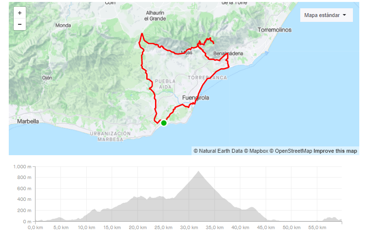
27. LA CALA – REFUGIO DE JUANAR – MIRADOR
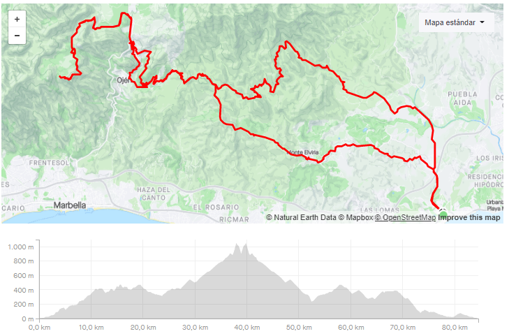
-
DISTANCIA/DISTANCE: 84,58km.
-
DESNIVEL POSITIVO/POSITIVE SLOPE: 2393m
-
Our LINK in Strava.
- Our LINK in Komoot.
- DIFICULTAD/DIFFICULTY: Alta.
- VIDEO – https://www.relive.cc/view/vYvrV1J7Vxv
Ruta de alta dificultad que en su punto final llega al Mirador de la Cabra, situado en las cimas de Marbella. Antes hay que pasar por Ojén por una carretera secundaria donde se tienen buenas vistas al pueblo.
High difficult route that ends at the Mirador de la Cabra, located on the peaks of Marbella. First you have to go through Ojén by a secondary road where you have good views of the town.
28. LA CALA – ISTAN

-
DISTANCIA/DISTANCE: 98,41 km.
-
DESNIVEL POSITIVO/POSITIVE SLOPE: 2,625 m.
- Our LINK in Strava
- Our LINK in Komoot.
- DIFICULTAD/DIFFICULTY: ALTA

Esta ruta de ciclismo de 98,4 km y 2.625 m de desnivel conecta La Cala de Mijas con Istán, pasando por Monda y Ojén. Combina tramos pavimentados y de tierra, incluyendo ascensos exigentes como la subida a la Ermita de las Tres Cruces, con pendientes de hasta el 13,9%. Es ideal para ciclistas que buscan un desafío en un entorno natural con vistas panorámicas.
This 98.4 km cycling route with 2,625 m of elevation gain connects La Cala de Mijas to Istán, passing through Monda and Ojén. It combines paved and dirt sections, including demanding climbs like the ascent to the Ermita de las Tres Cruces, with gradients up to 13.9%. It’s ideal for cyclists seeking a challenge in a natural setting with panoramic views.
29. LA CALA – LA MAIRENA
-
DISTANCIA/DISTANCE: 41,88km.
-
DESNIVEL POSITIVO/POSITIVE SLOPE: 1001.m.
-
Our LINK in Strava
- Our LINK in Komoot.
- DIFICULTAD/DIFFICULTY: Media.
- VIDEO – https://www.relive.cc/view/vE6JnXD2Zx6
Ruta que sube por uno de las subidas mas famosas de la zona, la subida al centro de drogodependencia de Mijas. Tiene paso por uno de los ultimos bosques mediterraneos de la zona, y como curiosidad en uno de los puntos pasa por un gran mansión del artista Julio Iglesias.
A route that goes up one of the most famous climbs in the area, the climb to the drug center of Mijas. It passes through one of the last Mediterranean forests in the area, and as a curiosity at one of the points passes a large mansion of the artist Julio Iglesias.
30. LA CALA – MIJAS – FUENGIROLA- LA CALA

-
DISTANCIA/DISTANCE: 48,14 km.
-
DESNIVEL POSITIVO/POSITIVE SLOPE: 870 m
-
Our LINK in Strava.
- Our LINK in Komoot.
- DIFICULTAD/DIFFICULTY: Alta.

Esta ruta de gravel de 48,1 km y 870 m de desnivel conecta La Cala de Mijas con Mijas y Fuengirola, ofreciendo una combinación de tramos pavimentados y de tierra. Incluye ascensos moderados y descensos técnicos que desafían al ciclista. Es ideal para quienes buscan una experiencia variada en un entorno natural.
This 48.1 km gravel route with 870 m of elevation gain connects La Cala de Mijas to Mijas and Fuengirola, offering a mix of paved and dirt sections. It includes moderate climbs and technical descents that challenge the cyclist. It’s ideal for those seeking a varied experience in a natural setting.
CITY BIKE
FROM TERRAL BIKE SHOP
31. CITY BIKE – MALAGA – MUELLE UNO
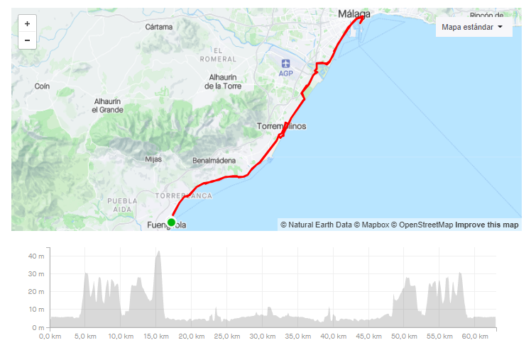
-
DISTANCIA/DISTANCE: 60,07km.
-
DESNIVEL POSITIVO/POSITIVE SLOPE: 257.m.
- Our LINK in Strava
- Our LINK in Komoot
- DIFICULTAD/DIFFICULTY: Baja
- VIDEO – https://www.relive.cc/view/v26M7rzW33v
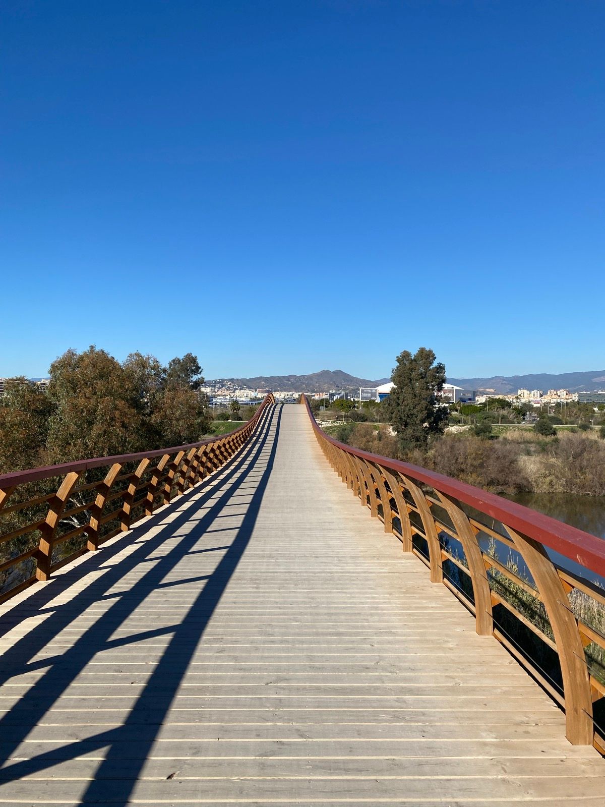
Ruta ideal para hacer en familia a la largo de la costa hasta Malaga. Se conecta con Malaga atraves del nuevo puente de madera sobre el rio Guadalhorce.
The ideal route to go with the family is along the coast to Malaga. It connects with Malaga through the new wooden bridge over the Guadalhorce River.